In ancient times, development of urban areas can be linked to the beginning and development of agriculture after the Neolithic revolution and also to the development of metal technology. The first civilisation came up in Egypt, Mesopotamia, China and India in around 3000 BCE. In the Indian subcontinent, like in other parts, first urbanisation is related to copper or bronze. The Harappan civilisation which flourished in the north-west frontier with big cities of that time like Mohenjodaro, Harappa, Dholavira, Rakhigarhi, etc. had trade connections with other ancient civilisations. However, this magnificent civilisation disappeared around 1700 BCE. After the decline of the first urban centres, a hiatus is observed in archaeological evidence, and again around the sixth century BCE, the second wave of urbanisation started in the Indian subcontinent. This phase is generally divided into three parts: first concentrated in Upper Gangetic and Indo-Gangetic divide, the second phase spread to new regions like Lower Gangetic valley, Punjab, Sindh, Rajasthan, Gujarat, Orissa and Maharashtra and the third phase which witnessed urban prosperity throughout the Indian subcontinent.
The second phase is important in the region south of Vindhyas as the emergence of urban areas can be witnessed in this part for the first time. The same is the case in Maharashtra, wherein the early historic period is dated to around fourth century BCE. However, archaeologically general urban prosperity is witnessed in the subsequent period, mainly during the Satavahana period. These urban settlements include Paithan, Brahmapuri (Kolhapur), Ter, Pauni, Adam, etc. Most of these urban areas were fortified with a moat around the fortification. Among all these, Pauni is an important key site as it lay on the trade route coming from north to down south and connecting Uttarapatha and Dakshinapatha.
Pauni, according to local mythology, derived its name from a local mythical king named Pawan and it was referred to as "Pavan rajachi nagari" i.e. the town of king Pavan. According to some other oral traditions, the town was known as Padmavati. Situated on the right bank of the river Wainganga, the present town is a taluka place in the Bhandara district of Maharashtra. The region is surrounded by Umred-Karandla Wildlife sanctuary and is famous as a pilgrimage centre.
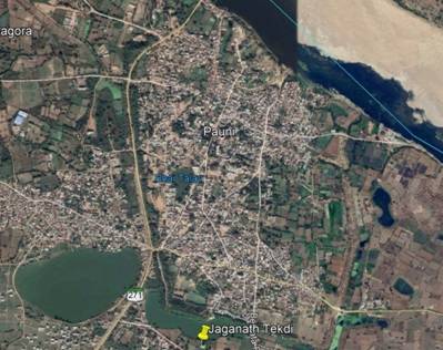
The ancient site is fortified with a brick rampart on three sides and the northern side is naturally bordered by the Wainganga river.

Figure 1: Satellite image of Pauni
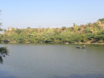
The ancient relics of the moat are preserved outside rampart at various places and some are still in use. Balasamudra is a lake to the south of the town, just outside the fortification and is a relic of the ancient moat.

Figure 2: Traces of rampart and moat at Pauni
The site was surveyed by Henry Cousens, John Marshall, H. Hargreaves, G.C. Chandra and these confirmed the historicity of the ancient relics. In 1964, a pillar inscription of Mahakshtrapa Rupiamma was discovered, which helped in fixing the connection of Kshatrapa with the ancient site. In 1967, a copper plate inscription of Vakataka King Pravarasena II was discovered from Pauni. Realising the importance of this ancient site, S.B. Deo of Nagpur University and J.P Joshi of Archaeological Survey of India conducted excavations at the site in 1968 and 1969; it was excavated again by Amrendra Nath of Archaeological Survey of India in 1994 which revealed the prosperity of this township. Importantly, the first excavation unearthed the relics of a stupa, thus revealing a vital chapter in the history of Buddhism in Maharashtra especially in Vidarbha.
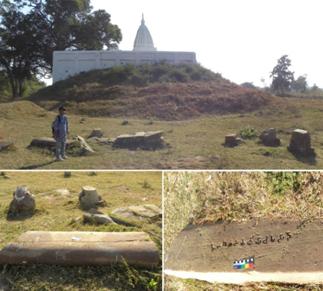
Three potential structural mounds were excavated in the first excavation, i.e. Jagannatha Tekdi, Chandakapur Tekdi and Hardolala Tekdi. The first two mounds were confirmed as stupa sites. Jagannatha Tekdi is located outside the southern rampart along the bank of Balasamudra and can be approached by following Pauni-Bhiwapur road and diverting to a road, which leads to Shukrawari Peth. The excavation revealed three main phases at Jagannatha Tekdi. The first period marked the occurrence of painted Northern Black Polished Ware and punch-marked coins and is dated to around 4th-3rd century BCE. The second phase is assigned to the Maurya-Sunga period, (3rd to 1st century BCE). This phase yielded Northern Black Polished Ware, black and red with slipped and unslipped redware. This period also witnessed findings of the inscription in early Brahmi and Shunga sculptures. In addition, it provided the evidence of encasement, pradikshina patha and gateways of the stupa. The third period had Red Polished Ware and red slipped ware with Satavahana and kshatrapa coins.

Figure 3: Archaeological relics at Jagannath Tekdi
The diameter of the Jagannatha Tekdi stupa is recorded as 38.20 m. It was built with burnt bricks measuring 40x37x10 cms in the first phase. In the second phase, with enhancement and encasement of the original stupa, the diameter increased to 41.2 m. The Stupa was constructed using the box technique. Edicts found in the excavation are grouped into inscription on coping stones, on octagonal pillars of the outer railing, horizontal bars or suci, motif labels and fragmentary indeterminate stone inscriptions. It is reported that sculptural representations of the Jataka scenes are almost absent at the site. This feature is different from Bharhut. Another important point to note is no mention of any royalty or minister in the records. So the donations mostly came from people with devotion towards Buddhism.
The site has also yielded varied sculptures. Major sculptural pieces include railing with human sculptures, sculptures with Naga Mucalimda and a railing pillar with a human male figure and religious motifs, Yaksha figures especially Yaksha Kharamukha. Other minor sculptures and decorated motifs are found on coping stones, railing fragments and include fluted capital, human figure fragment, animal figure and floral patterns. Other miscellaneous archaeological artefacts include copper and iron objects, beads, glass objects, terracotta objects and stone objects.
The stupa at Chandakapur has a diameter of 41.60 m. It has no pradikshana patha or railing or gateways. Though bigger than Jagannatha tekdi stupa, the monument was very simple. The stupa was constructed following tier technique and can be assigned to circa 1st century BCE to 2nd century CE.
This excavation brought to light useful information regarding Buddhism in the region from the Ashokan Period. It proved that it was an important centre of Hinayana Buddhism in Vidarbha, and that Buddhism in the region flourished from c.4th/3rd century BCE until the 2nd/3rd century CE.
The 1994 excavations by Amarendra Nath was initiated to determine the chronology of the habitation area and correlating it with different phases of rampart construction. In total, five periods were recorded during the excavation. The first period saw the finds of black and ochre painted red ware, black and red ware and its plain variant and is assigned to pre-Mauryan times dating to c. 6th to 4th century BCE. The rampart is evident in this phase, revealing defence at the site with its first occupation. The second period witnessed the finds of Northern Black Polished Ware and silver punch-marked coins attributed to the Mauryan period (4th to 2nd century BCE). This period marked massive rampart construction from lateritic gravel cutting the earth. This structure measured 8.25m in height and 48.90m in width. The massive cutting of earth for rampart transformed it into a moat, measuring 55m wide and 8m depth. The third period is assigned to the Sunga-Bhadra period with finds of terracotta human figurines dating the 2nd century BC to the first half of the 1st century BCE. The fourth period is marked with brick fortification attributing the cultural horizon to Kshatrapa-Satavahana times, dating this phase to the 1st century BC to 3rd century CE. The fifth period was a disturbed horizon and nothing substantial was recorded. The cyclopean wall was recorded in this phase. This period is attributed to Vakatakas and dated 3rd to 6th century CE.
Numismatic evidence substantiates the history of the site until the eighteenth century CE. Late medieval fortifications with gateways made of ashlar masonry are still standing intact on the site marking the persistent defensive nature.
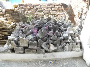
Considering the ancient relics and find of Vakataka copper plate from the site, Indian Numismatic Historical and Cultural Research Foundation (INHCRF) Nashik, under a collaborative project with the British Museum, surveyed the site and its surrounding 13 km radial block during 2015-16 archaeological field season. This resulted in the find of numerous settlement sites of Pauni. The survey recorded dispersed archaeological relics including stone objects, legged querns, ceramics, Garuda Khamb, etc.

Figure 4: Legged querns from the site
This appraisal of the archaeological finds from the site reveals the important role played by this ancient site in the spread of Buddhism in Mauryan times to down south. According to S. B. Deo, "Pauni must have played a commendable part in the transmission of Buddhism and Buddhist art and architecture further South, especially in Andhra Pradesh". The importance of the site in the ancient economic and political scenario is characterised by massive fortification. The occurrence of rampart from its first occupation justifies its strategic position. The site received prime importance during the Mauryan period when it was enclosed with a massive rampart. In the words of Amarendra Nath, "the site gained the status as a major garrison settlement encompassed by one of the largest defences of that era". The glorious stage at the site is marked in the Satavahana times by brick fortification which is substantiated by rich archaeological findings. Thus the archaeological findings reveal that Pauni in ancient times was an important religious centre devoted to Hinayana Buddhism and it was also a strategic political-economic centre.
Author details: Sitaram K Toraskar, Assistant archaeologist, Indian Numismatic, Historical and Cultural Research Foundation (INHCRF)
